
About Me
I am a data scientist with a background in physics and extensive experience in harnessing AI techniques for solving real-world problems. With one master’s degree in physics and a second master's degree in energy and climate, along with research experience in computational astrophysics, I have worked on projects involving time series analysis, modeling extreme events, and image processing. My interests lie in generative AI, Bayesian inference, latent variable models, diffusion-based models, and stochastic processes.
Publications
- Modeling X-ray Light Curves and Stochastic Behavior of Hydrogen Column Density in AGNs Using an Autoregressive (AR1) Model and Hamiltonian Monte Carlo: A Simulation-Based Inference Approach. N. Balafkan; J. Buchner. In preparation!
- Automated Satellite-Based Assessment of Hurricane Impacts on Roadways. M. Gazzea; A. Karaer; M. Ghorbanzadeh; N. Balafkan; T. Abichou; E. Erman Ozguven; R. Arghandeh. Published in IEEE (2022), Volume: 18, Issue: 3.
- Analyzing COVID-19 Impacts on Vehicle Travels and Daily Nitrogen Dioxide (NO2) Levels among Florida Counties. A. Karaer; N. Balafkan; M. Gazzea; E. Erman Ozguven; R. Arghandeh. Published in Energies (2020), Volume: 13, Number: 22.
- A large sample of Kohonen-selected SDSS quasars with weak emission lines: selection effects and statistical properties. H. Meusinger & N. Balafkan. Published in Astronomy & Astrophysics (2014), Volume 568, A114.


Awards and Grants
-
Winner of the Best Idea of the Month (Economic Operators’ Activity Category)
Recognized in a COVID-19 custom script contest organized by the European Space Agency (ESA) and the European Commission. Link to the contest. -
Saint Mary’s University, Canada (2014-2015)
Awarded a total of 20,000 CAD in grants from the Faculty of Graduate Studies and Research (FGSR) and the Natural Sciences and Engineering Research Council of Canada (NSERC).
Experience
Super-Resolution for Spatiotemporal Weather Data
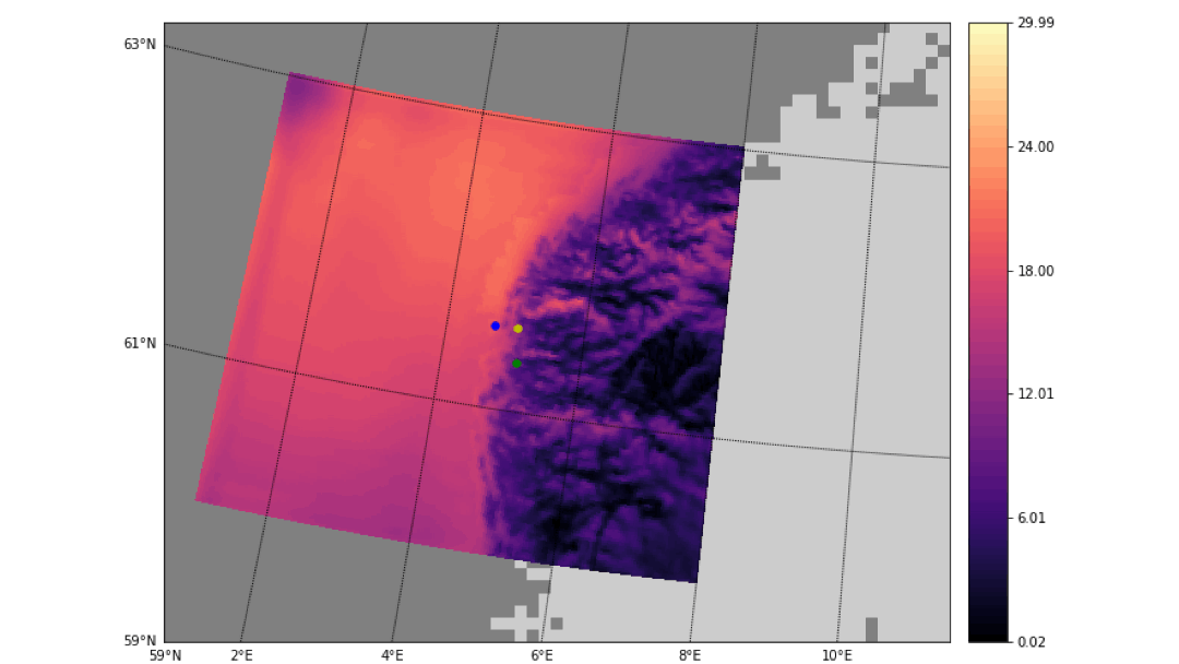
This project utilized a deep-learning-based model to generate a super-resolution map of a weather front impacting the western coast of Norway on January 1, 2021. The low-resolution ERA-5 dataset, with a \(30 \times 30 \, \text{km}^2\) resolution was fed into the model to produce a high-resolution output with a finer grid of \(2.5 \times 2.5 \, \text{km}^2\). PyTorch served as the core framework for developing and training the super-resolution model. The generated map reveals more detailed atmospheric features, with three highlighted points indicating the positions of synoptic weather stations.
Courtesy of [StormGeo]
Bayesian Time Series Modelling and Fourier Analysis
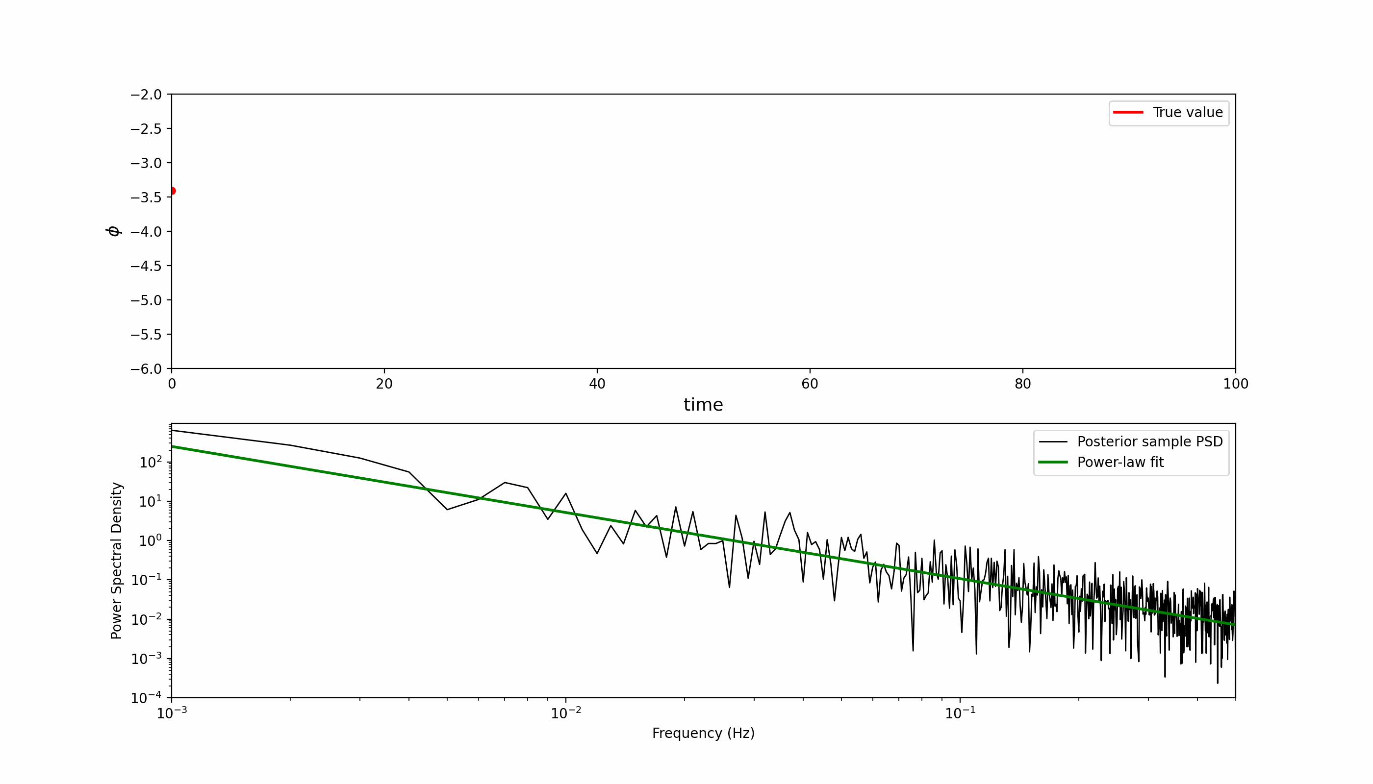
This project uses Hamiltonian Monte Carlo (HMC) to estimate the parameters of an autoregressive AR(1) process. The top plot shows the inferred values of the latent state variable (Φ) over time. The red line represents the true latent trajectory, while the dark lines depict 2,000 posterior samples obtained from the HMC sampler. To analyze the spectral properties of these samples, we apply the Fourier transform to each one and compute its power spectral density (PSD). The bottom plot shows the resulting PSDs, where each is fit with a power-law model to recover the underlying spectral slope, a key parameter of interest. This inference was performed using JAX for automatic differentiation and NumPyro, a probabilistic programming framework built on JAX, for efficient sampling and parameter estimation.
Gaussian Processes
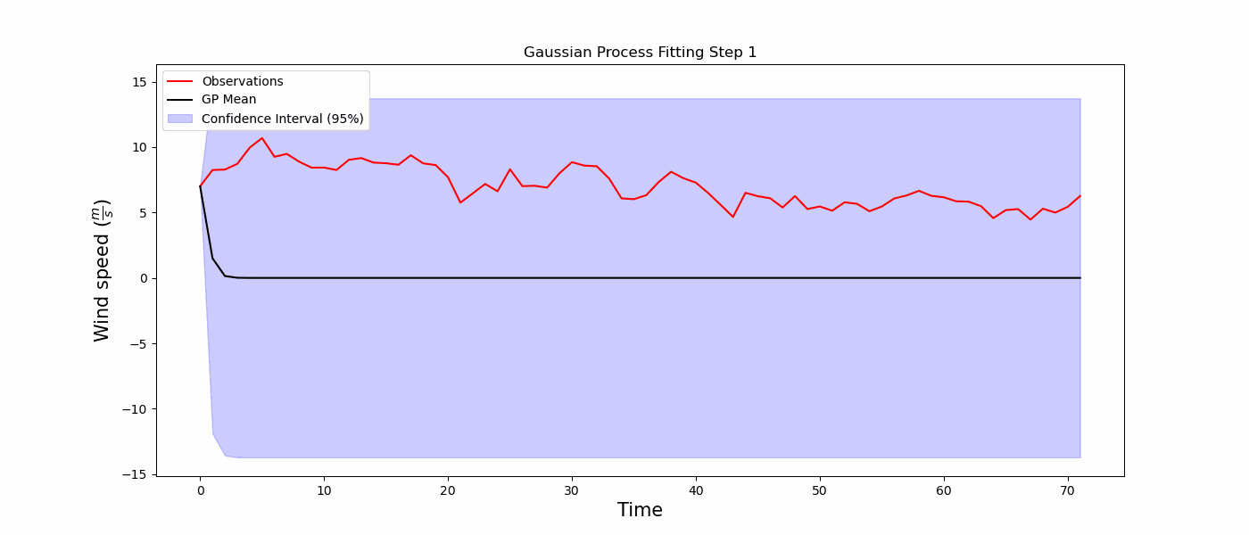
Wind speed is a critical atmospheric parameter, and precise forecasting of wind speed can offer substantial advantages across a wide range of applications. The visualization demonstrates the application of Gaussian processes to model the hourly wind speed data recorded over a 72-hour period. For this analysis, the scikit-learn library was utilized to facilitate the fitting process..
Synthetic Apperture Radar (SAR) Interferometry
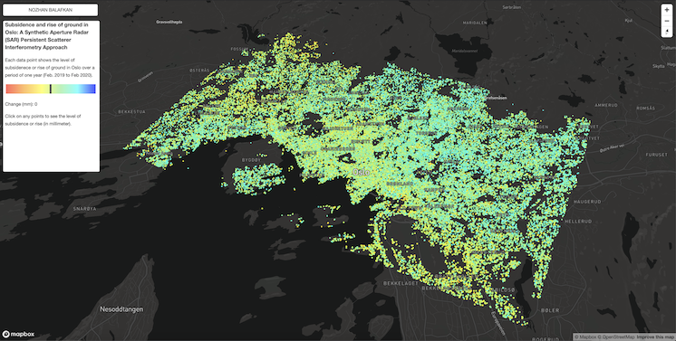
The goal of this project was to estimate ground subsidence and rise in the Oslo area, phenomena that pose significant risks to buildings and infrastructure over time. Synthetic Aperture Radar (SAR) interferometry was employed, a precise and advanced technique for monitoring surface changes on Earth. This project utilized Sentinel-1 satellite data, covering a one-year period from 2019 to 2020. The estimated data points, representing areas of ground movement, were geotagged and visualized using MapBox, providing an intuitive and informative map of subsidence and uplift across Oslo. Click on the image to explore the map.
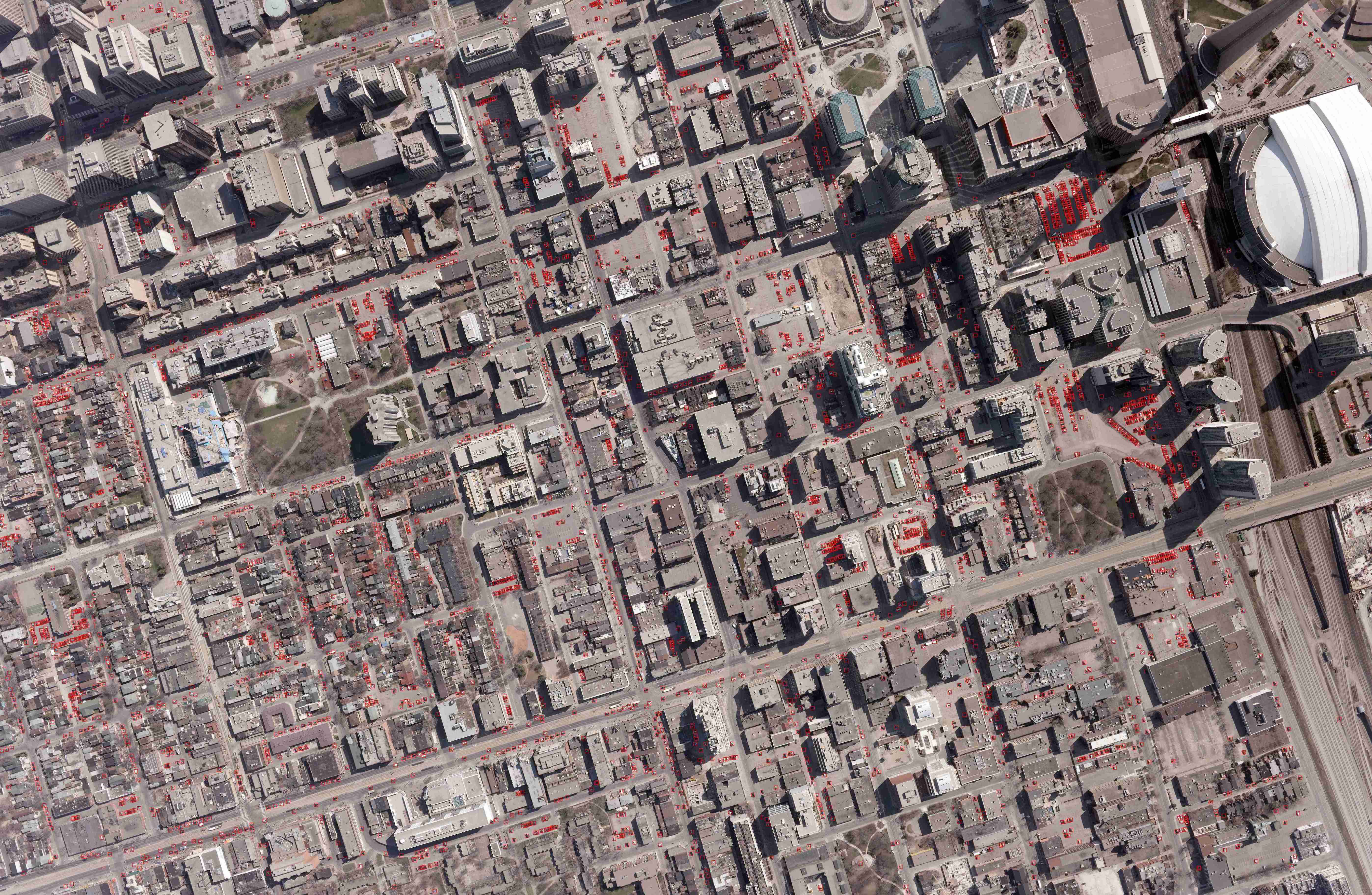
Object Detection in Satellite Imagery
This image showcases a deep-learning-driven system designed to estimate traffic density and parking availability in downtown Toronto, Canada. Each red bounding box marks a detected vehicle, identified using an object detection algorithm. The satellite image was divided into smaller tiles to enhance detection accuracy and enable efficient processing. The model leverages high-resolution satellite imagery to provide insights into urban traffic patterns and parking space occupancy. This proof of concept highlights the potential of AI for smart city applications, enabling better traffic management and infrastructure planning in busy urban areas.
Exploring the Three-Body Problem: A Computational Perspective
This video demonstrates a variation of the three-body problem, where three objects are placed at the vertices of a right triangle. The system is solved numerically using a set of fourth-order Runge-Kutta equations that I wrote in C++. At each time step, Newton’s equations of motion are computed, but at one point, the blue and green bodies diverge rapidly. This instability arises from a very small separation between these objects, leading to extreme forces. A potential fix involves setting a minimum distance threshold to prevent such divergences in calculations.
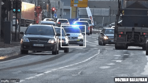
Object Detection
This proof of concept (POC) aimed to improve the safety of motorcycle riders by developing an early warning system for when they are approached by speeding emergency vehicles, such as police cars, ambulances, or fire trucks. High-speed motorcycle riders often struggle to hear sirens on highways, which poses a significant safety risk. The POC involved utilizing a lightweight and efficient object detection system, utilizing onboard cameras and an Nvidia Jetson Nano kit, mounted on an electric motorcycle. The goal was to create an efficient, real-time alert mechanism that could help riders respond quickly to approaching emergency vehicles.